


AutoPylot for Drones
4.8470.00 Reviews
App Specs
- Version
- 1.21.2
- Updated On
- License
- Free
- Downloads
- 100,000+
- Developer
- AutoPylot, INC
- Categories
- Productivity
- Platform
- Android
Screenshots
 Analysis by AppCompare
Flying a drone is easy to enjoy until the preparation becomes the difficult part. Before takeoff, I may need to think about nearby airspace, flight authorization, weather, insurance, a checklist, and the details of the mission itself. AutoPylot for Drones is built around that preparation problem. Rather than treating a flight as a single isolated task, it brings several planning tools into one productivity app from AutoPylot, INC.
After spending time with it, I see its strongest value in turning preflight planning into a repeatable workflow. The app is free to download, rated for Everyone, and available for devices running Android 9 or later. It has reached over one hundred thousand installs and holds a 4.8 average from around 4.2 thousand ratings, which suggests that its focused approach is resonating with many drone users.
That does not make it a universal replacement for every aviation or mapping tool. Its usefulness depends heavily on how seriously you plan flights and whether you want airspace, B4UFLY, LAANC, insurance, weather, checklists, and missions considered together. For casual pilots who simply launch in an obviously open area, it may feel more involved than necessary. For anyone who wants fewer last-minute surprises, the structure is much more compelling.
One planning workspace instead of scattered preflight checks
I find the mission-based setup useful because it gives each flight a clear place in my preparation, rather than leaving checks scattered across memory and separate tools. The next section looks at how I would use that structure in a real workflow, including when changing conditions call for a fresh decision.
The capability that matters most
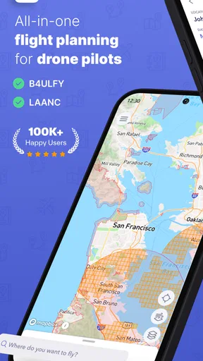
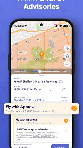
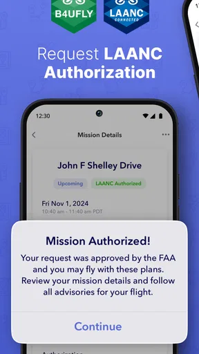
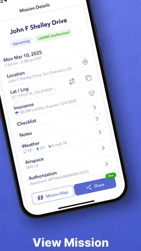
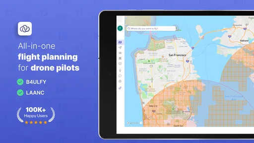
The most important capability here is not a flashy flight control feature. It is the way AutoPylot gathers the decisions that normally sit in separate places. Airspace information helps me think about where the aircraft can operate, while B4UFLY and LAANC address the practical side of checking and requesting access where applicable. Weather adds another layer of judgment, and checklists help turn good intentions into actions I can actually complete.
That combination changes the rhythm of a flight. In a less organized setup, I might look at the weather first, then remember airspace only after arriving, and finally realize that a required authorization step has not been handled. Here, the app encourages me to treat those items as parts of one mission rather than unrelated chores. The real benefit is not simply having more information; it is having a clearer order for using it.
I also appreciate that insurance appears in the same planning environment. Insurance is easy to ignore when a flight looks simple, especially when I am flying a familiar aircraft in a familiar place. Including it in the same preparation mindset makes the financial and operational side of drone work harder to overlook. It does not remove the need to understand the terms of any policy, but it gives that concern a visible place in the workflow.
Worth Reading Before You Choose

EA SPORTS FC Mobile 26 Is a Bigger Football Game, but It Takes Time

Flipboard Shows What News Apps Must Do Beyond the Feed

Switching to Android Auto Means Rethinking Your Driving Routine

Google Calendar Makes a Crowded Week Easier to Manage

Ludo King Makes the Most of the Minutes Between Plans

Baby Panda World Brings Quick Play to Modern Phones, but Its Game Library Feels Busy
The app is especially relevant to pilots who fly for work, repeat the same type of operation, or need to show that they prepared responsibly. A hobbyist can benefit too, but the value becomes clearer when a flight has a purpose, a location, and consequences if the plan is incomplete.
How the pieces work together in practice
I would begin by treating each outing as a mission rather than opening the app only when I am already standing at the launch point. That small change matters. A mission gives the preparation a destination and a purpose, so the airspace check, weather review, authorization process, and checklist are connected to a real flight instead of being vague tasks floating around in my head.
For a planned inspection, for example, I could first identify the operating area, review the relevant airspace information, and then check whether LAANC is part of the authorization process for that location. After that, I would look at weather conditions and work through the checklist before leaving. This sequence is more useful than checking items in whatever order I happen to remember them.
One practical tip is to avoid treating the checklist as a formality. I would use it to catch the small details that are easiest to skip when I am excited or in a hurry. The checklist is most valuable when it slows me down briefly before the motors start. That pause can expose a planning gap while it is still easy to fix.
Another useful habit is to separate “the app says I can investigate this flight” from “I have personally decided this flight is sensible.” Airspace tools, weather information, and authorization support can improve preparation, but they do not replace judgment. I still need to consider the actual surroundings, people nearby, the aircraft’s condition, and whether the planned operation is appropriate. AutoPylot helps organize that judgment; it should not be mistaken for an automatic safety decision.
The mission-centered approach also helps when plans change. If weather worsens, a location becomes unsuitable, or the timing shifts, I can revisit the preparation instead of relying on memory. That is a subtle advantage over a collection of separate apps: the changed plan remains connected to the rest of the flight rather than becoming a new mental checklist.
A realistic everyday scenario
Imagine I have arranged to capture aerial images of a property in the afternoon. The job may look straightforward, but the preparation still has several moving parts. I would use AutoPylot to frame the flight as a mission, inspect the airspace around the property, and determine whether a LAANC request is needed. I would then review the weather close to the intended operating time instead of relying only on an earlier forecast.
Before leaving, I would work through the checklist and confirm that the mission still makes sense under the current conditions. If authorization is required, I would want that handled before I am on-site and under time pressure. If the weather has become marginal, the app’s planning structure makes it easier to recognize that the correct action may be postponing the flight rather than forcing the original schedule.
At the location, the app is most useful as a final planning reference, not as permission to stop thinking. I would still look around for changing conditions and unexpected obstacles. The difference is that I arrive with the administrative and preparation work already considered. That makes the actual flight feel calmer and gives me more attention for framing, battery management, and the people around the operation.
This is where the app can outperform a basic weather app or a general notes application. Those tools may handle one part of the process, but they do not naturally connect a flight location with airspace awareness, authorization planning, insurance considerations, and a repeatable checklist. The advantage is organizational rather than dramatic, but organizational improvements are exactly what prevent avoidable mistakes.
Where the workflow is genuinely strong
AutoPylot is at its best when I have enough complexity to benefit from structure but not so much complexity that I need a specialized enterprise aviation system. It fits a pilot who wants one place to prepare a recreational outing, a property shoot, a survey-style visit, or a recurring operation.
The inclusion of B4UFLY and LAANC is particularly useful for pilots who are still learning how airspace planning fits into everyday drone operations. Instead of discovering these concepts one at a time, I can encounter them as connected parts of a flight plan. That makes the learning curve more practical: I understand not only what each item is, but when it belongs in my preparation.
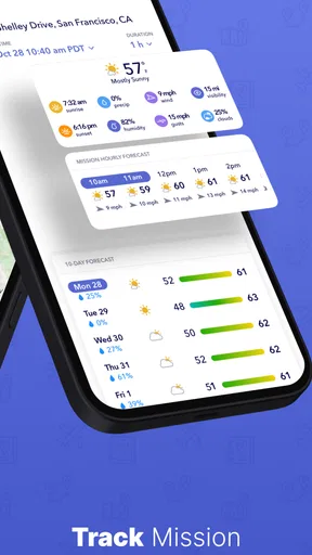
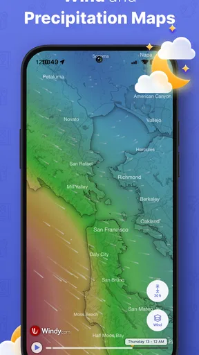
The weather component also has a practical effect beyond deciding whether to fly. It encourages me to think about timing. A mission that is acceptable in the morning may not be equally sensible later, and a checklist completed hours before departure should not create false confidence if conditions change. I find the app most helpful when I use it more than once: during initial planning, shortly before departure, and again if the schedule or location changes.
There is also a useful trade-off in having insurance visible alongside operational planning. Some pilots may see insurance as a separate business matter, but connecting it mentally to the mission makes sense. The right coverage can depend on the kind of flying being done, so I would use the app as a prompt to review that issue, not as a substitute for reading policy details carefully.
Trade-offs and points of friction
The same breadth that makes AutoPylot useful can make it feel busy. A person who only wants a quick weather glance may not want to move through airspace, authorization, insurance, and checklist considerations every time. If my flight is spontaneous and low-stakes, opening several planning sections may feel like more process than the outing deserves.
There is also a learning curve in understanding what each planning element means. B4UFLY and LAANC are not interchangeable ideas, and a new pilot may need time to understand how airspace information relates to authorization. The app can put the tools near one another, but I still have to learn the underlying responsibilities. That is a strength for structured learning, but it is not instant simplicity.
Another limitation is that organization can create a false sense of completion. Checking boxes is not the same as evaluating a changing environment. A completed checklist cannot see every person, tree, vehicle, or temporary restriction at the launch site. I would never let a finished mission override direct observation or current rules.
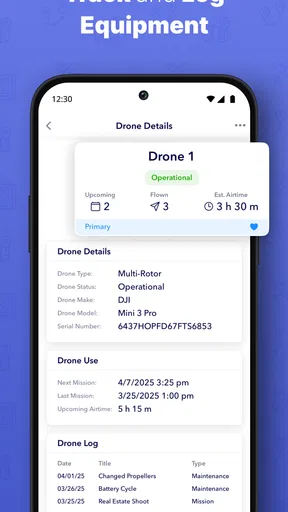
The app also should not be judged as a full replacement for every tool a professional pilot might already use. A specialist may need deeper mapping, detailed operational records, editing tools, aircraft-specific telemetry, or a more elaborate team workflow. AutoPylot’s appeal is the connected preflight layer. If I need a complete production or fleet-management system, I would look beyond it.
Because the app includes in-app purchases ranging from $3.99 to $39.99 per item, I would pay attention to which parts of the experience are available without payment and which optional tools matter to my own routine. The free entry point makes it easy to evaluate the workflow, but anyone planning regular professional use should consider the total cost of the features they actually need rather than assuming every capability is included at no charge.
Who gains the most from using it
I think the strongest audience is the pilot who repeatedly asks, “What do I need to check before this flight?” Newer drone owners can use the app to build a habit around airspace, authorization, weather, and checklists instead of treating them as advanced concerns. More experienced pilots may appreciate the reduction in mental overhead, especially when flights happen at different locations.
It is also a good fit for a small operator who handles several kinds of jobs but does not want a complicated management platform. A property photographer, inspection contractor, or independent creator can use the mission concept to keep preparation tied to a particular assignment. The value increases when a missed step could mean a wasted trip, a delayed client, or an avoidable operational problem.
Recreational pilots can benefit when they travel to unfamiliar places. In that situation, relying on memory from a familiar neighborhood is risky. A structured review of the new airspace and current conditions is more sensible, and the checklist gives the trip a consistent starting point. I would especially recommend this approach to someone who tends to make decisions in the car park rather than before leaving home.
On the other hand, I would not make AutoPylot my first recommendation for someone who wants only a minimal launch companion. If I fly rarely, stay in simple locations, and already have a trusted method for checking the relevant conditions, the extra planning structure may not feel worthwhile. Likewise, professionals with an established stack of specialized tools may see this as a convenient supplement rather than a central system.
What the free app is like as a starting point
The free price is important because it lowers the risk of trying a planning workflow before committing to it. I can see whether the mission-based approach suits me, whether the airspace and authorization tools fit my routine, and whether the checklist habit improves my preparation. That is a better way to judge the app than deciding from the feature names alone.
The current version is 1.21.2, and the app was released on May 2, 2023. Those details place it in the category of an established, actively identifiable tool rather than an unnamed concept, while the install base and rating show that it has attracted a meaningful group of users. I would still evaluate it according to my own flying area and workflow, because drone requirements and practical conditions can vary widely from one operation to another.
For a new user, my advice would be to create one ordinary mission first rather than trying to understand every section at once. Use a familiar location, compare the app’s planning sequence with the way you currently prepare, and notice where it catches something you usually forget. Then try it for an unfamiliar location or a time-sensitive task. That is where the difference between a collection of utilities and a connected workflow becomes easiest to judge.
My final take on AutoPylot for Drones
I recommend AutoPylot to pilots who want preparation to be more deliberate without assembling a separate tool for every question. Its central strength is the connection between airspace awareness, B4UFLY, LAANC, weather, insurance, checklists, and missions. Used thoughtfully, that connection turns preflight planning from a vague mental exercise into a sequence I can repeat and review.
It is not a magic safety button, and it is not automatically the best choice for a pilot who needs advanced professional records or a very lightweight experience. The app asks me to spend more time planning, which is precisely why it may feel unnecessary for the simplest flights. But when a flight has a location, a purpose, and real consequences if I overlook something, that extra structure earns its place.
For me, the deciding question is simple: do I want to remember every preflight step myself, or would I rather have a mission-based workspace that prompts me to consider the important pieces together? If the second answer sounds familiar, AutoPylot is a practical productivity companion worth trying. Its best result is not a more exciting flight; it is a better-prepared one.
Pros
- Supports automated flight planning for more consistent drone missions.
- Helps reduce pilot workload during repetitive aerial surveys.
- Useful route tools can improve coverage and mapping efficiency.
- Designed to help users maintain awareness of flight progress.
- Can save time when repeating established inspection routes.
Cons
- Requires careful setup to avoid inaccurate routes or unsafe flight paths.
- Compatibility may vary between drone models and mobile devices.
- Automated missions still need active pilot supervision throughout.
- Advanced features may be difficult for beginners to learn quickly.
- Weather
- GPS
- and signal issues can interrupt planned flights.
FAQs for AutoPylot for Drones
What is AutoPylot for Drones, and what can it do?
AutoPylot is a drone flight-planning and control application designed to help pilots organize, operate, and review drone missions from a mobile device. Depending on the supported drone and account setup, it may provide tools such as map-based planning, automated flight routes, camera control, telemetry monitoring, and mission recording. Before downloading, check whether your specific drone model, controller, operating system, and region are officially supported.
Which drones and devices are compatible with AutoPylot?
Compatibility is one of the most important points to verify before installing AutoPylot. The app may not work with every drone, remote controller, phone, or tablet, and some features can vary by model. Review the current compatibility list in the official store listing or the developer’s documentation. You should also confirm the required Android or iOS version, available storage, GPS access, and whether a compatible controller or internet connection is needed.
Is AutoPylot suitable for beginners, or is previous drone experience required?
AutoPylot can make mission preparation more organized, but it should not be treated as a replacement for pilot training or responsible decision-making. Beginners may appreciate the visual planning tools and flight information, yet automated routes still require careful checking before takeoff. New users should learn the drone’s manual controls, understand return-to-home behavior, practice in an open area, and follow local aviation rules before attempting advanced or autonomous missions.
Does AutoPylot require an internet connection, GPS, or a subscription?
The exact requirements depend on how you use the application and which features are available for your drone. Internet access may be needed for signing in, downloading maps, syncing missions, updating data, or activating certain services, while GPS and location permissions are commonly required for mapping and flight-related functions. Some features may also be limited by a paid plan, in-app purchase, or account type, so check the current pricing and permissions before downloading.
Is it safe and legal to fly a drone using AutoPylot?
AutoPylot can assist with planning and control, but the pilot remains responsible for every flight. Automated features do not guarantee that a route is safe, legal, or free from obstacles, signal loss, restricted airspace, people, buildings, or changing weather conditions. Always maintain the required level of supervision, verify local drone regulations, inspect the planned route, keep the drone within permitted operating limits, and be ready to take manual control whenever necessary.


